Ikebukuro (池袋), a part of Toshima ward, is a large commercial and entertainment district of Tokyo, Japan. It is the location of the Toshima ward offices, Ikebukuro station and several extremely large department stores. It is located at 35°43′48″N, 139°42′40″E.
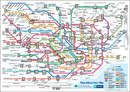
At the center of Ikebukuro is the train and subway station, a huge urban gathering shared by Japan Railways, the Seibu Ikebukuro Line and the Tōbu Tōjō Main Line. It is one of the main commuter hubs in the Yamanote area of western Tokyo. Ikebukuro Station is the busiest subway station in Japan and the second busiest railway station overall, second only to Shinjuku Station. Approximately one million people pass through the station each day.
Around the station are the Seibu and Tōbu department stores. Confusingly, Seibu, written with the characters for "West" and "Musashi (province)" 西武, is on the east end of the station and Tōbu written with the characters for "East" and "Musashi" 東武, is on the west end. East of the station, on the site of Sugamo Prison, stands Sunshine 60, which was Tokyo's tallest building at the time of its construction. Marui and Mitsukoshi also have department stores in the area. The principal electronics retailer in Ikebukuro is Bic Camera.
The old village of Ikebukuro stood to the northwest of the station. Most of the area on which modern Ikebukuro is built was historically known as Sugamo. In the Taishō and Shōwa periods, the relatively low land prices attracted artists and foreign workers, who lent a somewhat cosmopolitan atmosphere to Ikebukuro.
The kanji for Ikebukuro literally mean pond bag. Outside the west exit of Ikebukuro station near an entrance to the Yurakucho New Line is a small plaque explaining three origins of the name Ikebukuro. The first is that in the northeastern part of the village there was a lake shaped like someone holding a bag. The second is that there was once a large number of lakes in the area of various sizes (thus implying a bag full of lakes). The third is that long ago a turtle came out of the lake carrying a bag on its back.
There is a small statue of an owl located near the center of the city called Ikefukurō-zō (いけふくろう像), meaning lake owl statue. It may be a hint of the true origin of the name given to Ikebukuro, but it was more likely constructed as nothing more than a joke, a play on words and as a point of interest by the city administration. Perhaps because of this, the owl statue has become a famous meeting place along the lines of the statue of Hachiko located outside of Shibuya Station.
The area which was once called Ikebukuro-mura (池袋村) became known simply as Ikebukuro in the 7th year of the Showa Period, 1932.
Shinjuku History
In 1634, during the Edo period, as the outer moat of the Edo Castle was built, a number of temples and shrines moved to the Yotsuya area on the western edge of Shinjuku. In 1698, Naitō Shinjuku had developed as a new (shin) station (shuku or juku) on the Kōshū Kaidō, one of the major highways of that era. Naitō was a daimyo whose mansion stood in the area; his land is now a public park, the Shinjuku Gyoen.
Shinjuku began to develop into its current form after the Great Kantō earthquake in 1923, since the seismically stable area largely escaped the devastation. Consequently, West Shinjuku is one of the few areas in Tokyo with many skyscrapers.
The Tokyo air raids from May to August 1945 destroyed almost 90% of the buildings in the area in and around Shinjuku Station. The pre-war form of Shinjuku, and the rest of Tokyo, for that matter, was retained after the war because the roads and rails, damaged as they were, remained, and these formed the heart of the Shinjuku in the post-war construction. Only in Kabuki-cho was a grand reconstruction plan put into action (Ichikawa, 2003).
The present ward was established on March 15, 1947, with the merger of the former wards of Yotsuya, Ushigome, and Yodobashi.
In 1991, the Tokyo Metropolitan Government moved from the Marunouchi district of Chiyoda to the current building in Shinjuku.
Shinjuku Transportation
Shinjuku is a major urban transit hub: JR Shinjuku Station sees an estimated 3 million passengers pass through each day, making it the busiest station in the world. It houses interchanges to three subway lines and two privately owned commuter lines, as well as the JR lines.
Rail
- JR East
- Yamanote Line: Takadanobaba, Shin Okubo, Shinjuku Stations
- Chūō Main Line, Sobu Main Line: Yotsuya, Shinanomachi, Shinjuku, Okubo Stations
- Saikyo Line, Shonan-Shinjuku Line: Shinjuku Station
- Tokyo Metro
- Marunouchi Line: Yotsuya, Yotsuya Sanchome, Shinjuku Gyoenmae, Shinjuku Sanchome, Shinjuku, Nishi Shinjuku Stations
- Yurakucho Line: Ichigaya, Iidabashi Station
- Tozai Line: Kagurazaka, Waseda, Takadanobaba, Ochiai Stations
- Namboku Line: Iidabashi, Ichigaya, Yotsuya Stations
- Tokyo Metropolitan Bureau of Transportation
- Toei Shinjuku Line: Akebonobashi, Shinjuku Sanchome, Shinjuku Stations
- Toei Oedo Line: Ochiai Minaminagasaki, Nakai, Nishi Shinjuku Gochome, Tocho-mae, Kokuritsu Kyougijou, Ushigome Kagurazaka, Ushigome Yanagicho, Wakamatsu Kawada, Higashi Shinjuku, Shinjuku Nishiguchi Stations
- Toden Arakawa Line: Omokagebashi, Waseda Stations
- Odakyu Electric Railway Odawara Line: Shinjuku Station
- Keio Corporation Keio Line, Keio New Line: Shinjuku Station
- Seibu Railway Seibu Shinjuku Line: Nishishinjuku, Takadanobaba, Shimo-ochiai, Nakai Stations
Highways
- Shuto Expressway
- No.4 Shinjuku Route (Miyakezaka JCT - Takaido)
- No.5 Ikebukuro Route (Takebashi JCT - Bijogi JCT)
- National highways of Japan
- Route 20 (Shinjuku-dōri, Kōshū Kaidō)
Shinjuku Sight Seeing
Shinjuku-gyoen (the Shinjuku Imperial Gardens)
This is the most popular sightseeing spot in Shinjuku. Shinjuku may have a reputation as ‘an urban area,’ but it is certainly not without a garden. Shinjuku-gyoen is an oasis within skyscrapers, and one can enjoy its beauty throughout the four seasons. Its 100th anniversary of founding is in 2006.
Shinjuku Chūō Kouen (Shinjuku Central Park)
This is a big park neighboring the skyscrapers of the Tokyo Metropolitan Government. This park is essential for businessmen to have a break during their busy weekdays, and for children to play at weekends.
Tokyo Tocho (The Tokyo Metropolitan Government)
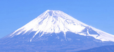
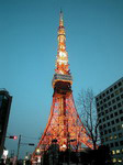
Since 1991, Tokyo Tocho has been a symbol of Shinjuku. It has an observation room on the 45th floor, which is 202 meters high. From here, one can see the Diet Building and Tokyo Tower, and weather permitting, Mount Fuji.
Kyu Ogasawara tei (The Ogasawara House)
This is a Spanish style house built for Earl Ogasawara in 1927. This European style building is now used as a restaurant run by a private enterprise.
Waseda daigaku ‘Okuma kodo’ (Waseda university 'Okuma auditoriums')
This is a symbol of the Waseda university and a landmark for people around the university.
Meiji Jingu Shoutoku kinen kaigakan (The Shotoku anniversary museum in the Outer Gardens of Meiji Shrine)
This is the most outstanding and magnificent building in the Outer Gardens of Meiji Shrine. A straight long avenue beginning at the front of the museum becomes golden with the leaves colour in autumn. The Outer Gardens of Meiji Shrine were selected as one of 100 most beautiful places in Tokyo.